![](/images/other/stat-length.png)
![Trail On foot The Municipal District of Muinebeag - Rathanna Slí na Sláinte - Photo](https://media.geolcdn.com/t/1900/400/027ab5df-7ee9-4de6-a8a8-c4d7d2918c44.jpeg&format=pjpeg&maxdim=2)
Rathanna Slí na Sláinte
SityTrail - itinéraires balisés pédestres
Tous les sentiers balisés d’Europe GUIDE+
![Length](/images/other/stat-length.png)
Length
5.4 km
![Max alt](https://static1.geolcdn.com/siteimages/upload/files/1508320355ic_sort_altitude_max_24dp.png)
Max alt
137 m
![Uphill gradient](https://static1.geolcdn.com/siteimages/upload/files/1508320355ic_sort_den_pos_24dp.png)
Uphill gradient
52 m
![Km-Effort](/images/other/stat-length.png)
Km-Effort
6.1 km
![Min alt](https://static1.geolcdn.com/siteimages/upload/files/1508320355ic_sort_altitude_min_24dp.png)
Min alt
93 m
![Downhill gradient](https://static1.geolcdn.com/siteimages/upload/files/1508320355ic_sort_den_neg_24dp.png)
Downhill gradient
53 m
![Boucle](https://static1.geolcdn.com/siteimages/upload/files/16400158638029165_repeat_loop_refresh_sync_direction_icon.png)
Boucle
Yes
Signpost
Creation date :
2025-02-06 12:29:42.861
Updated on :
2025-02-06 12:29:42.861
![On foot](https://static1.geolcdn.com/sitytour/trail-icons/100.png)
1h22
Difficulty : Easy
![Scan this QR Code to open this trail in the SityTrail application](https://capi.geolives.com/qq0zvz2zws4bq2lad0pu/sitytour/trails/4342857/qr.png?size=200)
FREE GPS app for hiking
About
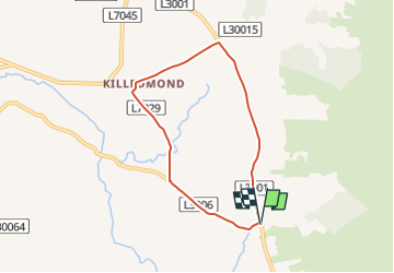
Trail On foot of 5.4 km to be discovered at Unknown, County Carlow, The Municipal District of Muinebeag. This trail is proposed by SityTrail - itinéraires balisés pédestres.
Description
Trail created by Slí na Sláinte - Irish Heart Foundation.
Positioning
Country:
Ireland
Region :
Unknown
Department/Province :
County Carlow
Municipality :
The Municipal District of Muinebeag
Location:
Rathanna
Start:(Dec)
Start:(UTM)
647616 ; 5829832 (29U) N.
Comments
Trails nearby
![Trail On foot The Municipal District of Muinebeag - Knockmullgurry Slí na Sláinte - Photo](https://media.geolcdn.com/t/375/260/a783b142-d39b-4cca-a7e9-d3077f4df79b.jpeg&format=jpg&maxdim=2)
![On foot On foot](https://static1.geolcdn.com/sitytour/trail-icons/100.png)
Knockmullgurry Slí na Sláinte
On foot
Easy
The Municipal District of Muinebeag,
Unknown,
County Carlow,
Ireland
![](/images/other/stat-length.png)
7 km | 8.2 km-effort
1h 52min
![](https://static1.geolcdn.com/siteimages/upload/files/16400158638029165_repeat_loop_refresh_sync_direction_icon.png)
No
![Trail On foot The Municipal District of Muinebeag - Walshestown Slí na Slainte - Photo](https://media.geolcdn.com/t/375/260/a783b142-d39b-4cca-a7e9-d3077f4df79b.jpeg&format=jpg&maxdim=2)
![On foot On foot](https://static1.geolcdn.com/sitytour/trail-icons/100.png)
Walshestown Slí na Slainte
On foot
Easy
The Municipal District of Muinebeag,
Unknown,
County Carlow,
Ireland
![](/images/other/stat-length.png)
7.5 km | 9.6 km-effort
2h 10min
![](https://static1.geolcdn.com/siteimages/upload/files/16400158638029165_repeat_loop_refresh_sync_direction_icon.png)
Yes